Profile Photo

Hassam Ali

GIS Engineer | Cartographer

Geospatial Developer

&

Web GIS Applications and Geo-Visualization Enthusiast

Hi! I'm

HASSAM ALI

GIS Developer

GIS Engineer

Cartographer

&

Web GIS Applications and Geo-Visualization Enthusiast

Profile Photo

Protfolio

Browse through some of my projects showcasing my skills and technical abilities.

No projects match your search

Try refining your query by adjusting the keywords in the search bar or selecting a different project type from the available options.

Web Map

The Unemployed States of America

HTML CSS JavsScript Leaflet
In March 2020, state governments all over the US began implementing state-wide lockdowns of various length in respond to the arrival of COVID-19. Government ordered lockdowns resulted in record level of unemployment. This map illustrate the impacts of lockdowns on unemployment levels in the US during the first three quarters of 2020.
Web App

Geospatial Application for Transportation & E-commerce

HTML CSS JavsScript Leaflet
Lorem ipsum dolor sit amet, consectetur adipisicing elit. Sed quae quo voluptatem quibusdam. Lorem ipsum dolor sit, amet consectetur adipisicing elit. A, dolore.
QGIS Plugin

Enforcing Downhill Steady Gradient on the Polyline Data

Python GDAL PyShp
Lorem ipsum dolor sit amet, consectetur adipisicing elit. Sed quae quo voluptatem quibusdam. Lorem ipsum dolor sit, amet consectetur adipisicing elit. A, dolore.
Desktop App

Langugage Learning Application

Python SpaCy PySpellChecker
Lorem ipsum dolor sit amet, consectetur adipisicing elit. Sed quae quo voluptatem quibusdam. Lorem ipsum dolor sit, amet consectetur adipisicing elit. A, dolore.
Paper Map

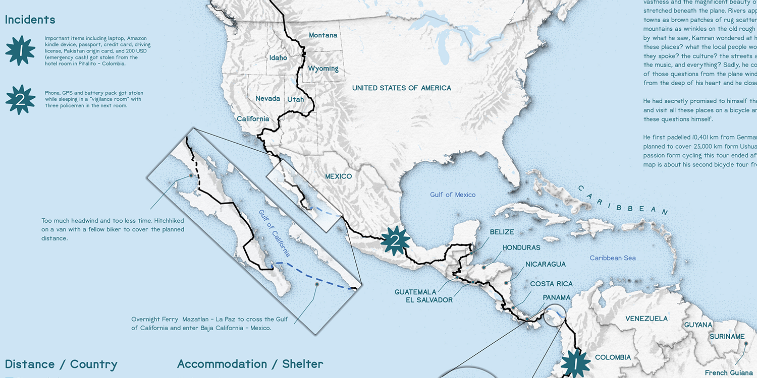
Kamran on Bike

ArcGIS Pro Inkscape
kamran on bike project image
This map visualizes the extraordinary cycling expedition of Kamran Ali, known as Kamran on Bike, who pedaled over 33,000 kilometers from Ushuaia, Argentina—the southernmost city in the world—to Prudhoe Bay, Alaska. Spanning the length of the Americas, this route showcases not only physical endurance but a deep spirit of exploration and cultural storytelling.
Poster

Bathymetry of Gwadar, Pakistan

Inkscape
This poster showcases the captivating bathymetry of Gwadar, Pakistan — a coastal region where land and sea blend into dramatic forms. Viewed from above, the contours reveal the hidden depth and beauty beneath the waves, offering a unique perspective of this strategic maritime location.

Curriculum Vitae

Education

NUST logo
2013 - 2017

Bachelor of Geoinformatics Engineering

National University of Sciences and Technology (NUST), H-12, Islamabad-Pakistan

2013 - 2017

  • CGPA = 3.78 / 4
    In the U.S. grading system, higher is better.
  • Thesis: Mapping the concentration of Air Pollutants using Geospatial Technologies
TUM logo
2020 - 2022

Erasmus Mundus M.Sc. in Cartography

Technical University of Munich, Munich-Germany

2020 - 2022

  • CGPA = 1.7 / 5
    In the German grading system, lower is better
  • Thesis: Pattern-driven Analysis of Pedestrian Movement
University of Münster logo
2024 - Present

M.Sc. Geoinformatics and Spatial Data Science

University of Münster, Münster-Germany

2024 - Present

Experience

Vodafone logo
Aug 2021 - Oct 2021

GeoAnalyst

Vodafone GmbH, Düsseldorf-Germany

Aug 2021 - Oct 2021

  • Conducted geospatial analysis to identify optimal 5G network sites across Germany
  • Developed a Python-based pipeline to automate data processing and dynamically generate results, significantly improving efficiency and decision-making
  • Automated service publishing and related tasks using ArcGIS API for Python, enabling a smooth transition to a new enterprise server
  • Developed Python scripts to automate routine workflows and tasks, increasing team efficiency and reducing manual effort
State emblem of Pakistan.svg
Oct 2017 - Sep 2020

GIS Officer

Government of Pakistan, Rawalpindi Pakistan

Oct 2017 - Sep 2020

  • Designed and produced maps and geodata visualizations for reports and web applications
  • Developed Python scripts to automate geospatial workflows and routine tasks
  • Created, managed, and validated geospatial datasets, ensuring high data quality and consistency
  • Maintained and enhanced a Python-based spatial decision support system to assist in data-driven planning
  • Supported the development of geospatial web applications and contributed to database design and management
  • Processed and analyzed satellite imagery for remote sensing applications, including land use & land cover mapping and change detection
Logo of LMKT.svg
Aug 2016 - Sep 2016

GIS Intern

LMKT - Islamabad, Pakistan

Aug 2016 - Sep 2016

  • Built a custom Python add-in for ArcGIS to calculate bearing and distance between two points
  • Created spatial datasets and performed satellite image classification for a web-based GIS application in smart agriculture
  • Modeled multiple routes using ArcGIS Model Builder to support geospatial analysis
  • Processed, verified, and mapped electricity distribution networks for a power utility company
Logo of NDMA.svg
Jun 2016 - Aug 2016

GIS and IT Intern

National Disaster Management Authority - Islamabad, Pakistan

Jun 2016 - Aug 2016

  • Developed a complaint management system using OpenLayers, PHP, and GeoServer to visualize and manage spatial incidents
  • Processed and classified satellite imagery (Landsat 8, Sentinel-2A) for flood extent mapping and damage assessment
Logo of DHAI.svg
Aug 2015 - Sep 2015

GIS Intern

Defence Housing Authority - Islamabad, Pakistan

Aug 2015 - Sep 2015

  • Converted sector plans from AutoCAD (DXF) to GIS-compatible data-formats
  • Conducted data quality assurance checks to ensure spatial accuracy and attribute consistency
  • Supported GIS mapping initiatives through data preparation and validation

Skills

Data Management and Quality Assurance Geodata Analysis / Spatial Analysis Cartography and Geovisualization Satellite Image Analysis Digital Mapping and Image Processing

Workflows and Task Automation WebGIS Map Services & APIs Database Management Systems (DBMS)

Technologies

ArcGIS / ArcGIS Pro QGIS ERDAS IMAGINE PostGIS / SQL GeoServer Python JavaScript HTML & CSS Git and Docker

Awards

President's Gold Medal

For best academic performance in "Bachelor of Geoinformatics Engineering" session 2013-2017

Erasmus Mundus Scholarship

For "Erasmus Mundus M.Sc. Cartography Program" 2020 intake.

Merit-based Scholarship

In all semesters of bachelor’s degree

Languages

  • English:  C1
  • German:  A2

Contact

Get in Touch

Drop a Line

Your Name

Your Email

Message

All the content on this website and associated pages is the exclusive property of Hassam Ali and is protected by international copyright laws. Any reproduction, redistribution, scraping, training of AI models (including but not limited to machine learning and large language models), or any other form of automated or manual data extraction is strictly prohibited without prior consent. Unauthorized use may result in legal action.